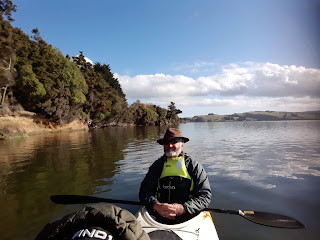
Wednesday, 2 October 2019

Central Otago Lakes, Cycle Trails and Great Walks

Historic Cromwell - Bill and his mate!
Leaving Queenstown to move on through Cromwell and Lake Dunstan to spend the night by the lake. We walked the burbs of Cromwell returning by the river, me in a simple shirt as the weather seemed to have warmed up.
Cycling the Clutha Trail

Beautiful mountain views on the trail.

30 Km round loop from Albert Town
We then moved onto Wanaka to camp on the side of the lake at Boundary Creek - a Doc Camp Site towards the top of the lake. It was very blustery here as it was a bit exposed to the wind. However we found a little spot out of the wind behind the trees. The next morning was equally as windy, but fine enough to have a walk around the beach. The Driftwood was amazing and it would have been great to have had a little fire there that night but it wasn't nice enough to stay. As we knew Kidds Bush was only a few minutes back down around on Lake Hawea, we headed down there.
Kidds Bush Doc Camp turned out to be lovely as we remembered it from our time with Peter & Margot when we did a kayaking trip down here back in 2014. We kayaked 10 lakes in 10 days!
The camp is slightly off the main road and not signposted which keeps many tourists out, probably contrived for that reason. The road is a dirt road and somewhat narrow in places. Being part of the main loop around the South Island, if this was better known I'm sure the road would probably be chaos with hundreds trying to come in each day. As it was, the camp had about 6 campers in every night. Lake Hawea is very low compared to what it can be. I would suggest at least 5 to 10 metres lower than it should be. This is probably not unusual at this time of year coming out of winter and the generation needed to keep New Zealand warm.
Boundary Creek at the top of Lake Wanaka

Lake Hawea on sunset at Kidds Bush

The view out over Hawea from the Sawyer Burn track

Dinner time at Kidds Bush

The next morning we headed up Sawyers Burn track - a very steep ascent on the hills immediately behind the camp to the bushline. The views from this vantage point where amazing and many photos were taken before having a light lunch and heading back down to camp. Probably tougher than the going up as it severely tests your knees and thighs. We made it back for a well deserved cold beer at the bottom.
The next day we headed towards Wanaka once more but this time via the village of Hawea. We did a walk through the village returning via the foreshore noting the large cribs being built there now. Some of them were truly stunning and as usual empty. The village is idyllically placed on the shores of the lake but somewhat exposed to the winds. I'm sure it would be a lovely summer place to be.
Just down the road to Albert Town which is where the crossing of the Clutha was bridged years ago. We took our bikes the next day around the peninsular to the outlet of the Clutha river.  Passing stunning Cribs (Baches), holiday homes or mansions, whatever you want to call them. And then onto Wanaka where we had a coffee and a bun. Well Sheryl had a coffee, Bill had the bun.
Heading back via the main road this time on a cycle track, we stopped and walked up the Iron Mountain. Another steep walk but affording fantastic views of Wanaka in all directions. Towards the southern divide and it's mountains, down the Cadrona Valley and out towards Lake Dunstan - very very scenic. An interesting point was how low the lakes were, Wakatipu Hawea, and Wanaka. All very low. Lake Dunstan appears to be at full capacity and this lake feeds the Clutha Dam so I'm guessing at this time of year this is desirable as they still need to be able to produce large amounts of power at a moment's notice.
That evening once more back on Lake Dunstan to spend the night. Meeting an Australian couple who were also camping on the side of the lake. It turns out that Russell and Jeanette were sugar cane farmers from Queensland. An interesting evening was spent listening to the philosophies of a Northland Queensland Cane Grower on how farming has been ruined by governments and other such stuff. A useful insight for Bill.
Looking over Wanaka from Iron Mountain


A very low Lake Wanaka at the Clutha Outlet

Views from the top of Iron Mountain
From Dunstan we headed straight through to Kinloch at the head of Lake Wakatipu, taking our rig through the narrow streets of Queenstown as there is no other way to get through. And Bill missing the turn off because it's not even signposted!! Which brought a 15 m towing rig through some very tight little corners and indeed straight over the top of one roundabout to get through town.
Kinloch is opposite Glenorchy, right around the top of the lake and to get there you must cross the Dart and Rees Rivers further back up the valley. These are large braided rivers making for difficult crossings in the day.
Kinloch I have never visited before. My grandparents would often take us for drives up to Glenorchy and Paradise as a young lad. Sheryl and I had also been to Paradise with my grandparents back in the late 70s when my grandparents still lived in Queenstown. Kinloch is still very much a small place with a few houses. A small YHA Lodge with restaurant and cafe but not overly busy this time of year. It is the starting point or rather the last road into here before starting the Greenstone and Caples tracks and back out the other side the Routeburn track.
A quick look on Google indicated a small 15 km loop walk around Lake Rere would be adequate for our needs. Driving from Kinloch to Elfin Bay we headed through a couple of fords, always fun. The track took us across farmland and then up a creek. We were dive bombed by magpies, one actually hitting Sheryl's ear, much to her consternation. From then on we walked with our walking sticks above our heads to try and deter their vicious swoops 😫.
Lake Rere at Kinloch

Looking at an earlier flood up the Greenstone River 

Looking up the Caple Valley

Lake Sylvan

An ore concentrator

Bill looking into the Burdens
Used to finely crush the ore.

The valley floor heading up the Rees river from the
Invincible Mine

The old mine shaft - now almost buried.
The walk up the creek through Beech Forest was beautiful and scenic but were just amazed at the amount of fallen beech trees, most probably from strong winds flattening whole areas. This was of some concerned as there were many trees still hanging and it was reasonably gusty on the day. Causing the sound of tortured timber frightening us as we went through parts of the forest. Eventually we came out to the small Lake Rere, where we had lunch and a breather. From here we carried on through the bush angling up towards the Greenstone River to a point where a stock bridge was. This area is still part of the Greenstone Station and part Doc Reserve and is grazed mainly by cattle. Signs  of cattle everywhere! As we were descending towards the river and the bridge I spotted an antlered deer running through the bush away from us but with such a quick glance, a photo was not possible. Following on down the Greenstone River  till we reached the Caples track and Caples river.
The Caples and Greenstone tracks through these valleys are a huge tourist attraction. You can see why much of Lord of the Rings was filmed in these areas.
By the time we returned to the car, it was a 5 hour loop tramp - 15 kms. Some very steep sections, and lovely waterfalls following the river through some remarkable landscapes A good day was had, returning to the bus for a well deserved meal.
The next day we headed back up the Dart River towards the start of the Routeburn Track where Lake Sylvan is nestled amongst regenerating beech forest. The area around Lake Sylvan was extensively logged back in the 1890's for timber, which was in short supply for the building going on in Queenstown and Central Otago due to the Gold Rush demands. Lake Sylvan loop takes about 2 hours if you take the old tramway loop. The track has recently been remade and is of excellent quality. Very flat indeed - one would get a wheelchair around most of it with little problem. From Lake Sylvan we returned to Glenorchy for a lakeside lunch before heading up the Rees Valley to the Invincible Mine. Gold miners abandoned the mine back around the 1930s when the gold ran out. Of interest is the mining gear left behind being the best example in New Zealand of some of the equipment used. I guess it's inaccessibility is why so much of the gear remained up there as it would be a mission to get it out. But we are told to spare a thought for those Miners that took the gear in the first place as it is a very steep track up and even with the use of horses, this would have been a mission in the day. The views afforded from up at the mine were absolutely stunning with the Rees Valley going for many many kilometres up into the mountains and looking down the valley back across to Kinloch and the Humboldt mountains. All snow capped and looking impressive.
From here it was back to Queenstown to spend a night at our luxury accommodation catching up on work and laundry.

Tuesday, 1 October 2019

Central Otago coming into Spring

Bill enjoying comprehensive guided tour.
On returning to Pounawea, Poss was to teach us how to whitebait. Poss and Bill went to the river to try their hand. Poss got two small feeds whilst Bill got 3, fish that is, kinda disappointing in many respects! The next day we went  again with worse luck, just enough for a fritter for Sheryl if you threw Bills one "bait" in. ☺☺☺
Poss & Bill (hidden) catching me a meal πŸ™

Old wharf piles used to load timber from 30 odd
timber mills in the area.

Bill just chilling on Lake Catlin

One stop truck shop.

OMG! Where does one start?
This was amazing, & only the far corner of the shed.

Coal Truck & Mine Nightcaps.

Jenny & Murray in a much smaller home πŸ˜„

Vertical shaft plunging nearly 400 metres.

Thomson Gorge Rd.
Looking back to the Lindis Pass

Trying to perfect the Selfie!

An restored rock stamper battery. 

Lunch time - keeping warm out of the wind.

A lovely walk around Kelvin Heights Peninsular

Boys working hard in the garden
Poss shook his head and went back to the farm, leaving us to our own devices, so the next day Sheryl and I both went out to catch fish. In some respects we did well as we came home with 48 fish, not a huge feed but enough to make a small fritter for Sheryl.🐟
We decided we would cut our losses and with the next day being calm and sunny, we launched the kayak and paddled up the Catlins River to Catlins Lake. A very tidal area being more of an estuary then a lake. Enjoying a very scenic and relaxed paddle over 3 hours drifting around with the tide, was a fitting end to our time in Pounawea.
On the road again we headed up the Balclutha valley stopping in at the farm to say thank you to Annette & Poss for their hospitality and use of their Crib. Another parcel of mail had arrived for us. Bill was very excited as usual.
We drove on to Lumsden via the back roads of Southland. Roads that we had never done before, the, lovely green rolling fields with thousands of newborn lambs gambolling together in the spring growth - lovely country to farm I'm sure.
We spent the night in Lumsden at the NZMCA camp, a familiar place for us now having stopped there several times before. It is conveniently placed, having routes to many different areas from there. The town names of Ohai and Nightcaps were familiar to me from my days in Southland however I don't believe I have ever been there. So being quite close, an expedition was mounted. Nightcaps and Ohai are coal mining towns, but this is now in decline. It boasted New Zealand's first private railway to bring out the coal for sale to industry and retail over many years. The State Railway taking control  many years later. It is still being used to take coal through to Timaru for Fonterra's Clandeboye Plant. Indeed so much coal is taken that you would wonder about their carbon footprint! The towns are in decline and are a sad reflection on what they must have been in past but they are still an interesting reminder of how things would have been with the hustle and bustle that went with a thriving coal mining industry back in the day.
A sign to a historic saw milling operation was spotted and we popped in to have a quick look before Sheryl could find a toilet. An amiable fellow came to meet us, John Eaves, after stopping his lawn mower and introduced us to his rambling collection of very old machinery, trucks, cars, boats, and indeed a large bush  sawmill. However it took a full half hour just to get to the sawmill looking around every piece of machinery along the way. Some  looking very very dilapidated but, he assured us, all in good working  condition.Well Mostly!!
We eventually got out to the sawmill and it was indeed a working sawmill, although hasn't been for a couple of years presumably. Powered by a traction engine rescued by himself,. He had completely built the sawmill from bits and pieces,every bit having a story, in the classic style of a working bush sawmill.
His yard was littered with old trucks, and I mentioned we had been to Bill Richardson's Transport World a few days earlier. He proudly lead me to a sad wreck of rusty dilapidated panels and wheels of a truck saying, "He hasn't got one of these!".
His shed was a sight to behold and as he walked me through it, he seemed to know what everything was and had been. Pointing to piles of what may be termed rubbish and telling me what it was, where it came from, and in many cases how many pounds or dollars paid. With a gleam in his eye indicating perhaps a shrewd bargain made. He was certainly a character, and if you ever get a chance to have a look round Nightcaps he would certainly be worth a visit. Especially if you are looking for a piece anything mechanical, or a whole truck, this may well be your one stop shop. It was getting on and  poor Sheryl was holding her own after two and a half hours so we cut  the visit short before a quick toilet stop, gulped pie and trip back to Lumsden picking up the bus and hitting through to Queenstown.
The trip through to Queenstown past  Kingston took us into very windy blustery weather coming down the lake.  By the time we got through to Queenstown the wind had abated somewhat and it was relatively calm. Jenny& Murray were and residence and we caught up over an evening meal laying plans for the next  3 days.
Our foray into four-wheel driving 18 months ago when we took the Suzuki through the Nevis Road had prompted Murray, and he had since bought himself a lovely Toyota Prado. I thought it was time we should christen the shiny Prado convincing him a trip through the Thompson gorge 4WD track was an absolute must. It took only a moment to decide that this would be a great adventure with much excitement, planning lunch, packing  blankets in case we got trapped, and chairs to make it comfortable, we all went to bed excited for tomorrows excellent adventure.
It transpired Jenny and Murray hadn't been to Bendigo either and this was on the route to the Thompson Gorge. So that was our first stop of the morning. For those that haven't been there, Bendigo is a deserted gold mining town on the flanks of the Dunstan Mountains, catching glimpses of the top of Lake Dunstan.   It has many deteriorating stone buildings built by the hard rock miners in the late Eighteen Hundreds. It is now a Doc Reserve and historical site of significance. It has many vertical mine shafts now mostly covered thankfully as small children and animals would be easily lost, with one shaft claiming to be nearly 400 meters deep. It is worthy of several hours nosing about as we have done previously having excellent interpretative panels,  but we settled for the quick introductory trip of about an hour to give J&M a taster, hopefully to return with others and have a good meander around  this historic relic of our gold mining past.
Coal miner.Behemoth.
We then headed on to Thomson Gorge. The road, naturally enough, is an old gold mining route and has gold mining equipment scattered along it's path if you take the time to look. We stopped at a stamper battery with an old drive deep into the hill which  Bill followed  for about 150 m with the aid of his phone torch till his courage ran out. The Gorge Road goes 30 km up one side of the Dunstan Mountains before descending  into  the Maniototo  at Omakau, 20 km north of  Alexandra. It is a reasonable road which generally could be done with a 2WD as the fords were reasonably shallow but prone to rapid deterioration with the weather.
We all enjoyed the ride even Sheryl, if she closed her eyes on  some of the steeper sections. It was a gentle ride in many respects, lots of photo opportunities before we arrived down  on the flat main road. Sheryl, to her own demise, then looked at the map as we were approaching Clyde for a hot drink at Oliver's and said there was another back route from Clyde to Bannockburn. It was only another short 4wd burst over the mountains so I managed to convince all into thinking this would be a fitting end to the day.
A little "Doerr Upper" in Nightcaps
After our drink in Clyde, we set forth on our next little adventure. It being about 5 we hoped it wouldn't be too late. The  Hawksburn track was again a lovely scenic ride thru the majestic Tor ridden landscape so prevalent in Central Otago. The light was fading as we finally arrived  back into Queenstown  after a stunning day of travel into  places that few people will get to see unless they take the long way home.
Jacks Point Golf Course looking stunning
"Water Hazard."
A quirk of our time with J&M had us meeting Murray's man that helps them with the lawns, Frank.It turned out he was from Lumsden and as a younger man, knew a couple of boys from Lumsden that had boarded with us in Invercargill. It turned out that he knew our house from when he used to visit the boys, back in the 70s, indeed remembered Mum being a nice lady with many kids and a big house.  I don't recall him as we did have many  visiting calling on our boarders back in the day. It's a small village isn't it!
 Jenny & Murray's neighbour David had invited them over to dinner at a new place they had just built, realising we were still here, invited us also. David and Leona have a fantastic small collection of vehicles which is their0 "thing"  and wanting a place close by to be able to work on them has had a house built specifically to house the vehicles.
Even the Chooks down here have plenty of room!
The house is fitting of the area, but instead of having many internal rooms is basically a large open space. It still has a kitchen and mezzanine floor able to accommodate some guests. The house has 6 vehicles and a couple of motorbikes in it. Including a little Messerschmidt 2 seater.  It was very interesting and a credit to David's vision of being able to display his toys. A very pleasant evening was spent with the couple, Jenny & Murray and also Frank and his wife Lynn.
It was time for J&M to head back to Auckland, so we dropped them off at the airport before departing ourselves toward Cromwell and Lake Dunstan. 

Tuesday, 24 September 2019

Southland and east through the Catlins

Big Bogies at Kingston
Leaving Queenstown to head southward, more snow had come through in the past 2 days making the mountains look beautiful but not too low to make it overly cold. 
We went down the side of Lake Wakatipu and into Kingston for lunch. It was good to see the Kingston Flyer looking like it might be up and running again for the summer – with new investors. The same Trust who are running the Blenheim to Picton Steamer. Fingers crossed they can make a go of it. For now the line is just to Fairlight and needs extensive renovation. The Cafe was at least open with a few clients enjoying this picturesque spot. Bill hopes they check the line out thoroughly as he has a few spikes in his collection from previous visits. 

Southlands rolling hills
On to Lumsden to the NZMCA camp for the night. It's lovely and quiet here and the trees had grown so much in 18 months since we last called in. There is a St John’s Op shop in the town where it is good to be able to restock our books. And when they are between $1 and $3 each, why wouldn't you? A great way to share your books around the country.
Onto Piano Flat to reminisce Bill’s childhood memories of being pack horses for a family friend who was gold fossicking (using a sluicing riffle boxs) and the family camping holidays that were had up here from Invercargill.
Purakaunui Bay with natural art 
We drove through beautiful back country roads – lovely rural scenery with the lush spring growth. We passed Waikaia Gold Limited's equipment parked up just out of Waikaia. In the past five years they have been dredging and extracted over 2 tonnes of gold over 5km of old river bed, only winding up last April 2019.
Waikaia Bottle House (Museum)
They are now remediating the land to flat pastoral farm land.
Up the valley following the Waikaia river and onto Piano Flat Doc Camp named after the piano player Harry Salek who entertained the early settlers and miners in mid to the late 1800s. Amazing how in those early days people could be so mobile with pianos!
It is a lovely Doc camp, there was only one other camper up here at this time of year. The sandflies were just loving the three of us! 

As it was sooooo wet the next day, it was great day for reading. When the sun came out in the afternoon we were able to walk the Piano Flat Track through the Beech Forest. It was very muddy but picturesque. Old water races from the gold mining days are throughout this forest. 
Piano Flat Waikaia River
We realised this week we had been 5 years on the road since leaving Nelson on the 27th of August 2014. It has been a great experience and who knows where or when it will finish. 
We woke the next morning to our windows frosted over on the inside! Very white outside with a heavy frost but beautiful and clear. We were to move on south but when we went to leave…… our double set of tyres at the rear of the bus had sunk into the very wet ground after yesterday's rain. Even trying to push it out with the Suzuki didn't work till Bill put a couple of bucket loads of gravel into the wheel tracks. Then I had another go pushing and we were out thankfully as there were not a lot of people around to help.
Piano Flat water supply! Ex Goldmining days
Not that it was a problem as we had plenty of food on board.😊 But it is the end of the month and I did have some work to get done that required cell coverage which there was very little of up here. Time to move on. 
Another lovely days travel through rural Southland and past remediated pastures mainly for dairy by the gold company.

A crisp morning at Piano Flat
We called in to the Croydon Air Museum at Mandeville for Bill to spend a few hours while I worked on the computer. The museum focused on wood and fabric De Havilland and Tiger moth planes. Amazing craftmanship, still flying today. As a bonus they are restoring a railway siding to commemorate the Lumsden Gore railway. Bill was in his element ✈
Moving onto Gore, where we haven't spent much time previously, to have a bit of a look around. We had the night at the AMP Show Grounds to enable us to visit the museums in the morning. The great Hokonui Moonshine Museum and Gore Museum and the lovely Carnegie Public Library building. Philanthropist Andrew Carnegie sponsored 18 libraries in New Zealand between 1908 and 1916 – one of these being in Gore. This building is now the Eastern Southland Gallery – having had a $1.2 million dollar make over back in 2002. It is a magnificent building – well worth a visit even if you aren’t into art.
Gore's Icon
An interesting period of Prohibition in this area and it’s illicit whisky making is well covered in the Hokonui Moonshine Museum – where the new Scottish Settlers came up against some police opposition. But with their canny ingenuity, they often outfoxed the Custom Men of the time. Some great stories. This museum is attached to Gore’s local area history museum which covers the likes of the Creamoata Factory and Sargent Dan. 
Making Hokonui Moonshine 

Onto Invercargill to park up at Dorothy Young’s once again, this time meeting up with sons Peter, Paul and Mark (it was 45 years ago Bill last caught up with them).
With it being whitebaiting season we were given a feed that Paul had brought for dinner but it got a bit late so was put in our freezer for another day😊

We also caught up with Bills nieces again, after our last visit 18 months ago. Natasha and Davinna and their husbands George & Malcolm. Bill's sister Sue had sadly passed away 10 years ago, so it's important to keep that family link with her family all living down here in Invercargill. We all meet up for lunch including Sue's husband Lennox.
Grid lock at the Youngs Invercargill

Luxury Motorhoming at Bill Richardson's Transport
 Museum -a must Do!
Our plan while down here was to visit Stewart Island which has been on our bucket list for some time. But unfortunately the weather did not play its part once again, so we will go away and come back another day.
While in Invercargill we visited Bill Richardson's Transport World. If you are ever in Invercargill this is a must-visit. Bill and I managed to spend 5 hours at the Museum (including lunch at their quirky Cafe).
From Invercargill we headed up the Catlins once again, this time from the southern end. Calling in to Fortrose (but realised we could get bogged in again and being up on a cliff - too far away for some gravel if needed) and onto Slope Point (Weir Reserve). We passed many whitebaiters along the way but not overly friendly. I guess they saw us as a threat thinking we were fellow fishers. They are quite possessive of their areas even though they are public lands.A parochial lot when it comes to whitebait. Tho true of the whole country we understand.😏

Oreti Beach - not so many bathers todayπŸ˜‰

Slope Point Light House

NZ's most southern point - Slope Point
On to Niagara falls through Curio Bay,( the Petrified Forest) and  Porpoise Bay. With the penguins starting to Nest, Doc people were roping off sections of the beach to protect the area for them.
We continued to travelling up every dead end road (because it was there!) in the Waikawa area. A few were closed before the end which we were told was due to vandalism and theft - people stealing batteries out of tractors etc. A shame as the roads are slowly being closed for casual public use.

Lovely rural rolling paddocks lush green and full of lambs which are really bouncy with their little tails wagging. 
Coverage was a bit marginal in this area so we had to go back to Curio Bay to do some work before doing the Waikawa museum which was full of the Districts farming origin - Flax, Sawmills, goldmining, whaling, and the areas schooling history. The Niagara Falls school is now a lovely Cafe. Logging started in this region for Dunedin’s housing boom in the gold rush years in the mid to late 1800s - there were sawmills still operating here in the early 1950's.

It was on to Papatowai Doc camp for the next couple of nights to do the walks in the area. McLean's Falls would have to be one of the better Falls we have seen in our time. Beautiful bushwalk through to the Falls which had been recently cleaned up after a huge rock fall.

Curio Bay - petrified forest (Bus in the background)

Niagara Falls School Cafe

Walkway through wetlands on the Tautuku River Estuary

Bill sharing wisdom with young men (Adam & Wills)

Southern Man. Purakaunui Bay

Rock formations Purakaunui Bay

Purakaunui Bay with Sealions in the sand dunes.
Calling into Owaka  to refresh supplies and water and had a lovely meal fish & chips for lunch. While here  with some phone reception we caught up with family and a bit of work. We then headed into Purakaunui Beach - another remote Doc Camp with a beautiful beach, huge cliffs and sea lions. Amazing rock formations but a freezing cold wind straight across from the Antarctic.  We met two young lads camping here too, Adam and Wills, who are rafting guides working in Queenstown (I know! Who would go on the rivers at this time of year!! Aussies! And other mad people!). They were spending their two days off in here to do some surfing.
We did a walk up the steep hillside to get onto the top of the cliffs. I know! Very brave of me. But I let Bill go out and do the edges!
It was a lovely wee spot to have some time out in. Apparently over the summer break it's pretty busy so will leave it for the tourists then.
NZ is lucky to have such an organisation as DOC who look after and protect these areas for all to enjoy. Long may it last.


Southern Man at McLeans Falls Catlins- another must do!